The walks, ranging from 1.5 to 6 miles, provide walks suitable for all
abilities. There are detailed descriptions for each walk with
highlighted maps and superb accompanying photographs. The book also
includes an introductory chapter providing general information about the
National Park along with walking and safety tips.
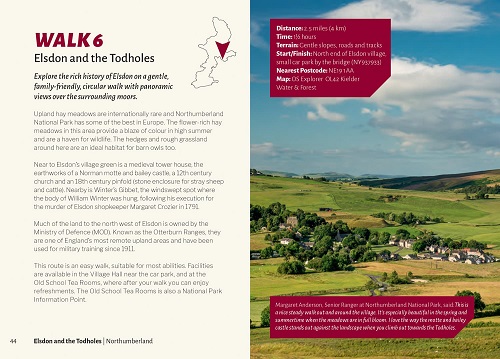
Each
of the walks is introduced with a simple locator map followed by a
brief description of the area, its geography and history and some notes
on things you will encounter on your walk.
Near the start of each walk
chapter there is a panel giving distance, time and briefly describing
the path conditions, and starting grid reference.
The major part of each
chapter is taken up with a large-scale map and a detailed point by
point description of the route along with navigational tips.
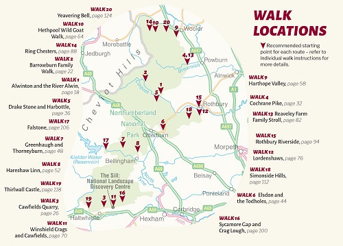
The walk locations are:
Alwinton and the River Alwin - 5 miles
Barrowburn family walk - 5 miles
Cawfields Quarry - 3.5 miles
Cochrane Pike - 4.5 miles
Drake Stone and Harbottle - 5 miles
Elsdon and the Todholes - 2.5 miles
Greenhaugh and Thorneyburn - 2.5 miles
Hareshaw Linn - 3 miles
Harthope Valley - 4 miles
Hethpool Wild Goat walk - 2 miles
Winshield Crags and Cawfield - 6 miles
Lordenshaws - 3 miles
Reaveley Farm family stroll - 2.5 miles
Ring Chesters - 5 miles
Rothbury Riverside - 1.5 miles
Sycamore Gap and the Crag Lough - 4 miles
Falstone - 2 miles
Simonside Hills - 4.5 miles
Thirlwall Castle - 2 miles
Yeavering Bell - 3.5 miles