With many glorious views, it encircles the capital at an average
distance of 7 miles from the centre and passes through some 50 green
spaces linked by stretches of water including the Thames and some of its
tributaries. The route is never far from public transport and
refreshment facilities, so you can divide it into as many long or short
sections as you need.
The official start is in Woolwich, but being circular you can start
and finish wherever you want. Going clockwise, the route follows the
Thames for a while, with a great view of the Thames Barrier, then heads
south-west through Maryon Park, Charlton Park, Woolwich Common and
Oxleas Wood to pass Eltham Palace, and on through Beckenham Place Park
to Crystal Palace Park. Then the route swings north-westerly through
Norwood Grove, Streatham Common, Tooting Bec Common, Wandsworth Common,
Wimbledon Park, Wimbledon Common (with its ancient windmill) and Putney
Heath to Richmond Park.
The Thames is encountered again and crossed at Richmond Lock, then
the route heads northwards through Syon Park, passing Syon House, to
pick up the Grand Union Canal at Brentford, then the River Brent at
Hanwell. Perivale Park leads to another branch of the Grand Union and
Horsenden Hill, then the route climbs again to pass between the elevated
and historic buildings of Harrow School and cross its playing fields.
Turning eastwards now, the route goes through a succession of small
parks to ascend Barn Hill, with a view of the famous arch of Wembley
Stadium, then Gotsford Hill with its 360-degree panorama. More
waterside walking follows beside the Brent Reservoir (Welsh Harp) and
Dollis Brook, then Mutton Brook leads through Hampstead Garden Suburb.
The route continues through one of Londons most heavily wooded areas,
in Highgate and Queens Woods, then follows a linear park along a former
railway line into Finsbury Park.
A section beside the artificial New River leads to Stoke Newington
Reservoirs, Clissold Park and Springfield Park. On its homeward stretch
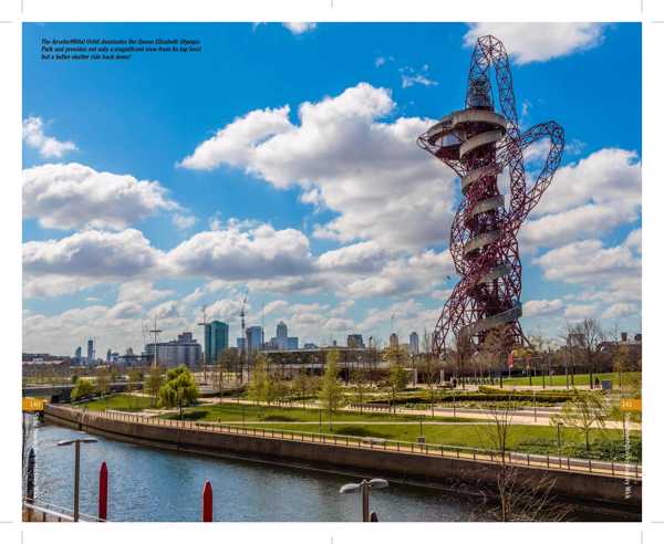
now, the route turns south-eastwards along the towpath of the Lee
Navigation all the way to the Queen Elizabeth Olympic Park, with views
of its stadium (home of West Ham United FC) and the amazing structure
known as the ArcelorMittal Orbit. An extraordinary raised embankment
known as The Greenway leads to a campus of the University of East London
and the vast Royal Albert Dock, now a watersports centre.
Finally, a promenade beside and beneath the Thames takes the route to
and through the Woolwich Foot Tunnel, back to where it started.
Of course, sometimes you must follow roads between these places, but
the route has been carefully designed to keep this to a minimum and
follow quiet, residential streets where possible. Much of it is level,
but you must be prepared to climb to some of Londons highest points.
The ground is mostly level and firm, but there will be some uneven
surfaces or grass, and it can get muddy in places after rain.