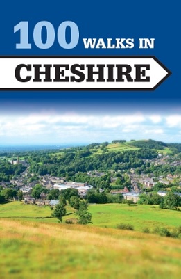
Each walk entry begins with start point, distance, summary, refreshment
locations and OS Explorer map references.
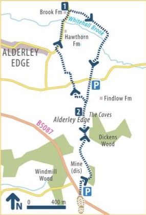
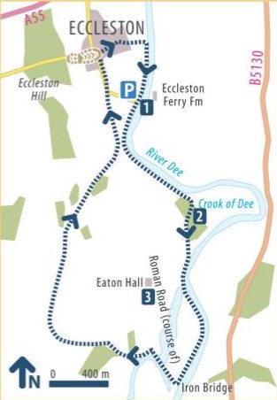
Detailed route finding
instructions follow in numbered paragraphs corresponding to numbers on
the clear coloured sketch maps.
Shaded panels provide information about
interesting sights along the way. Information about where to park and
places to eat and drink is also provided.
The walks are arranged in the
book by distance making it easy to select one to suit the time
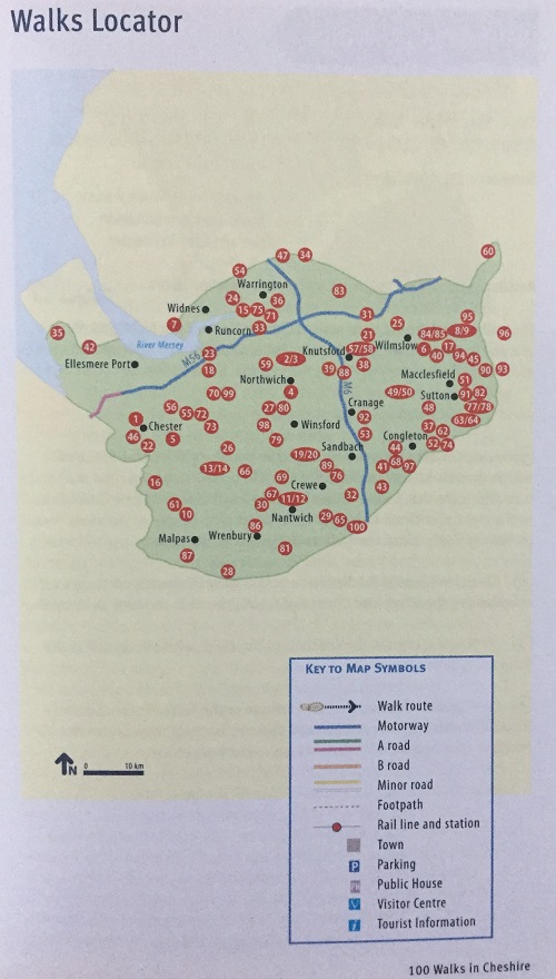
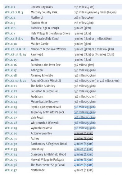
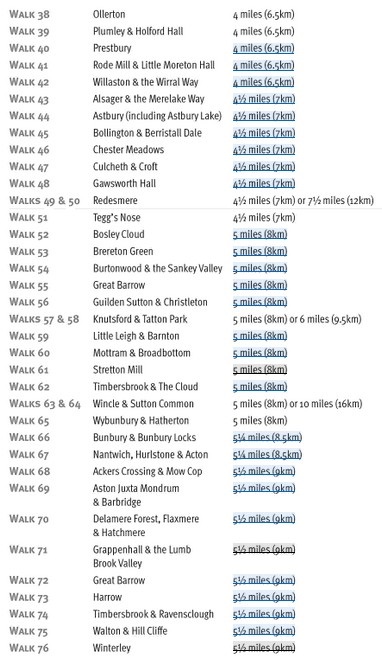
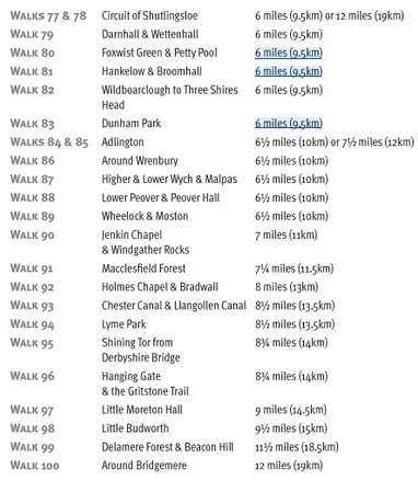
available. There is also a tabular listing of the walks and a location
map.
Full-colour mapping is included which is sourced from the Ordnance Survey.
Details of where to park and where to eat and drink are included and also places of interest to see along the way.
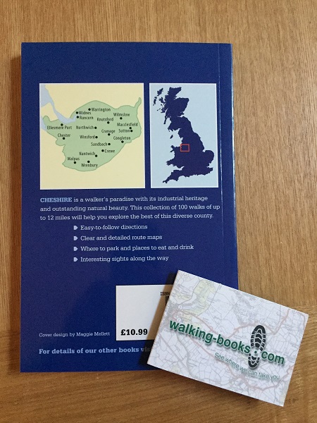
Easy-to-follow directions
Clear and detailed route maps
Full-colour mapping sourced from the Ordnance Survey
Where to park and places to eat and drink
Interesting sights to see along the way
SAVE £5 on RRP
Chester City Walls - 2.5 miles
Marbury Country Park - 2.5 miles
Northwich - 2.5 miles
Rowton Moor - 2.5 miles
Alderley Edge and Hough - 3 miles
Hale Village and the Mersey Shore - 3 miles
Macclesfield Canal - 3 or 5 miles
Maiden Castle - 3 miles
Nantwich and the River Weaver - 3 miles
Raw Head - 3 miles
Walton - 3 miles
Farndon and the River Dee - 3.25 miles
Adlington - 3.5 miles
Alvanley and Helsby - 3.5 miles
Church Minshull - 3.5 miles
The Bollin and Morley - 3.5 miles
Eccleston and Eaton Hall - 3.5 miles
Frodsham - 3.5 miles
Moore Nature Reserve - 3.5 miles
Styal and Quarry Bank Mill - 3.5 miles
Tarporley and Wharton's Lock - 3.5 miles
Vale Royal - 3.5 miles
Whitchurch and Wirswall - 3.5 miles
Wybunbury Moss - 3.5 miles
Acton to Swanley - 4 miles
Ashley - 4 miles
Barthomley and Englesea Brook - 4 miles
Daresbury - 4 miles
Glazebury and Hitchfield Wood - 4 miles
Heswall Village to Parkgate - 4 miles
Manchester Ship Canal - 4 miles
North Rode - 4 miles
Ollerton - 4 miles
Plumley and Holford Hall - 4 miles
Prestbury - 4 miles
Rode Mill and Little Moreton Hall - 4 miles
Willaston and the Wirral Way - 4 miles
Alsager and the Merelake Way - 4.5 miles
Astbury and Lake - 4.5 miles
Bollington and Berristall Dale - 4.5 miles
Chester Meadows - 4.5 miles
Culcheth and Croft - 4.5 miles
Gawsworth Hall - 4.5 miles
Redesmere - 4.5 miles
Tegg's Nose - 4.5 miles
Bosley Cloud - 5 miles
Brereton Green - 5 miles
Burtonwood and the Sankey Valley - 5 miles
Great Barrow - 5 miles
Guilden Sutton and Christleton - 5 miles
Knutsford and Tatton Park - 5 miles
Little Leigh and Barnton - 5 miles
Mottram and Broadbottom - 5 miles
Stretton Mill - 5 miles
Timbersbrook and The Cloud - 5 miles
Wincle and Sutton Common - 5 miles
Wybunbury and Hatherton - 5 miles
Bunbury and Bunbury Locks - 5.25 miles
Nantwich, Hurlestone and Acton - 5.25 miles
Ackers Crossing and Mow Cop - 5.5 miles
Aston Juxta Mondrum and Barbridge - 5.5 miles
Delamere Forest, Flaxmere - 5.5 miles
Grappenhall and Lumb Brook Valley - 5.5 miles
Great Barrow - 5.5 miles
Harrow - 5.5 miles
Timbersbrook and Ravensclough - 5.5 miles
Walton and Hill Cliffe - 5.5 miles
Winterley - 5.5 miles
Circuit of Shutlingsloe - 6 miles
Darnhall and Wettenhall - 6 miles
Foxwist Green and Petty Pool - 6 miles
Hankelow and Broomhall - 6 miles
Wildboarclough to Three Shires Head - 6 miles
Dunham Park - 6 miles
Adlington - 6.5 miles
Wrenbury - 6.5 miles
Higher and Lower Wych and Malpas - 6.5 miles
Lower Peover and Peover Hall - 6.5 miles
Wheelock and Moston - 6.5 miles
Jenkin Chapel and Windgather Rocks - 7 miles
Macclesfield Forest - 7.25 miles
Holmes Chapel and Bradwall - 8 miles
Chester and the Llangollen Canal - 8.5 miles
Lyme Park - 8.5 miles
Shining Tor from Derbyshire Bridge - 8.75 miles
Hanging Gate and the Gritstone Trail - 8.75 miles
Little Moreton Hall - 9 miles
Little Budworth - 9.5 miles
Delamere Forest and Beacon Hill - 11.5 miles
Around Bridgemere - 12 miles