The Howardian Hills, designated as an Area of Outstanding Natural Beauty
since 1987, covers an area of 79 square miles (204km²); consisting of
well-wooded hills and sequestered valleys, arable and pasture farmland,
hedgerows, designed parklands and picturesque villages.
The region has an astonishing heritage with numerous archaeological
and historical features, from Bronze Age burial mounds and Iron Age
earthworks to medieval castles and monasteries. Also, considerable
evidence exists of the Roman occupation, including a fort at Malton and
the remains of twenty pottery kilns at Crambeck.
After exploring the unspoilt countryside and experiencing the peace
and tranquillity of the area at close quarters, you will long to return
here, time after time.
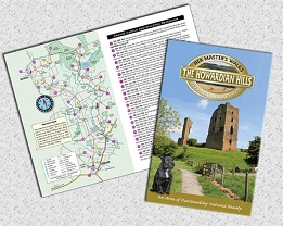
Each walk has a two page description, a colour map with
numbered arrow pointers and route directions with grid references to aid
map reading. All of the walks follow circular routes ranging from 5 to 8
miles (8.0 to 12.9km).
| Walks in the Howardian Hills |
|
| Husthwaite and Beacon Banks |
5.0 miles
|
| Ampleforth Abbey and the Studford Ring |
8.0 |
Stonegrave Minster and Caukleys Bank
|
6.75 |
| Crayke Castle and Oulston Reservoir |
8.0 |
| Hovingham Park, Cawton and Coulton |
7.5 |
| The Street Parishes of Ryedale |
7.5 |
| The City of Troy and Mug Dale |
6.0 |
| Castle Howard and Coneysthorpe |
7.0 |
Sheriff Hutton and Mowthorpe
|
7.5 |
| Kirkham Priory and the river Derwent |
7.5 |