The routes range from 6 to 9.5 miles and have been carefully chosen for
their scenic interest. You will find a mix of rolling countryside,
rugged hills, fertile farmland, river valleys, and ancient woodland.
The
routes often include sites of historic interest and always a good view.
Many of the walks make use of the Herefordshire Trail, a 150-mile
long-distance footpath around the county which links the five main
market towns. The Mortimer Trail and Offa's Dyke long-distance paths
also make an appearance.
Each of the walks begins with a panel
giving start location and parking with grid reference, distance, ascent,
terrain details, OS Explorer map sheet number, and public transport if
available.
The detailed navigation instructions are in numbered
paragraphs supported by a sketch map showing the paragraph numbers.
There are numerous coloured photographs throughout the book.
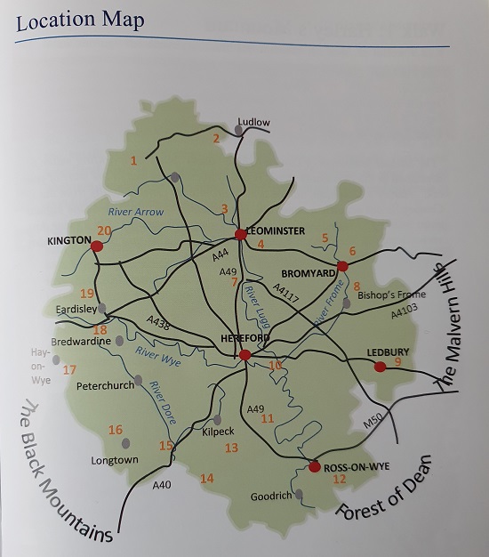
The walk locations are:
Harley's Mountain - 7 miles
Downton Castle - 10 miles
Richard's Castle - 7.5 miles
Bache Camp - 7 miles
Bringsty Common and Bromyard Downs - 6 miles
Hope-under-Dinmore - 7 miles
Frome Valley - 7 miles
Ledbury - 8 miles
How Caple - 7.5 miles
Little Dewchurch - 7 miles
Weston under Penyard - 8.5 miles
Kilpeck - 7 miles
Garway Hill - 6.5 miles
Ewyas Harold - 7 miles
Longtown - 7 miles
Hay-on-Wye - 6 miles
Arthur's Stone and the Golden Valley - 6.5 miles
Eardisley - 9.5 miles
Titley - 8.5 miles