The routes range from extended strolls to exhilarating
hikes, from under three to over ten miles, so there is something for
everyone.
Each walk includes a detailed, turn by turn description, an extract of
the large-scale OS map at 1:25,000 scale, photos and notes identifying
key features to look out for.
Walks include Suffolk's riverside meadows of the Stour and a walk
through Flatford and East Bergholt passes one of Constable's most famous
viewpoints. There is a choice of coastal walks, including routes
through Southwold, Shingle Street, Dingle Marshes, Thorpeness and the
Shotley peninsula.
The walk locations are:
Carlton Marshes and River Waveney - 2.75 miles
Southwold - 3.75 miles
Darmsden and Gipping Valley - 4.25 miles
Nowton Park and High Suffolk - 4.5 miles
Stoke-by-Nayland to Polstead - 4.5 miles
Shingle Street and Alderton - 4.5 miles
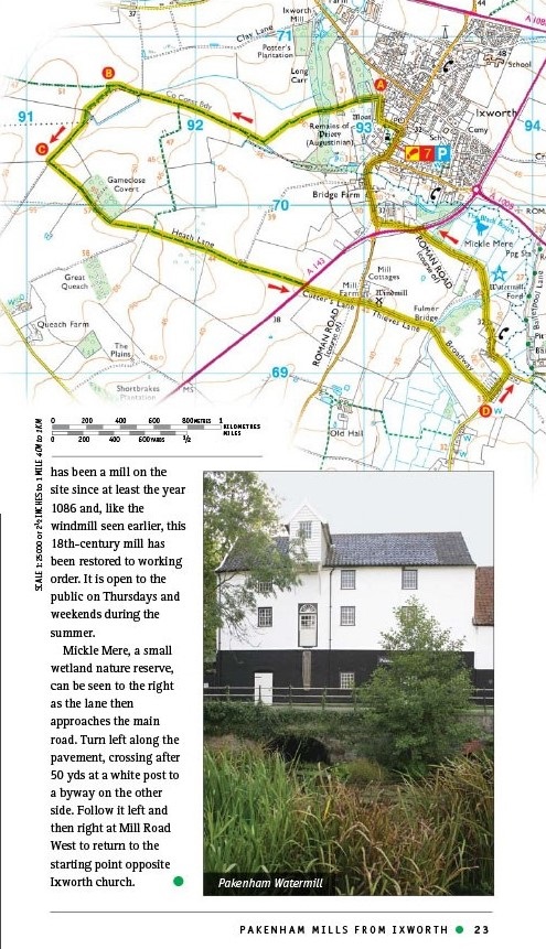
Packenham Mills from Ixworth - 5 miles
Covehithe and Benacre - 5.5 miles
Cretingham and Brandeston - 5 miles
Forest and Riverside from West Stow - 5.25 miles
Eye and Braiseworth - 5 miles
Framlingham - 5.5 miles
Flatford and East Bergholt - 5.5 miles
Long Melford - 5.5 miles
Somerleyton and Wadding Lane - 6.25 miles
West Row and Worlington from Mildenhall - 6.25 miles
Orford Coast and Country - 6.25 miles
Thorpeness from Leiston - 6.5 miles
Saxmundham, Kelsale and the Gull Stream - 7 miles
Lavenham and Brent Eleigh - 7.25 miles
Sudbury and its Water Meadows - 7.5 miles
Clare and Cavendish - 7.5 miles
Iken and Tunstall Forest - 7.75 miles
Barham, Baylham and Coddenham - 8 miles
Kersey and Hadleigh - 8.25 miles
Thorpe Morieux - 9 miles
Denham Castle and the Three Churches - 9.25 miles
Sutton Hoo, Shottisham and the River Deben - 10 miles