
To find the book, map or guide you are looking for, first select the area you are interested in by moving your mouse over the map and then click on a region to view our range.


walkshire


Top 10 Walks: The Yorkshire...

Price: £12.95

A superb pocket sized map of the footpaths in Upper Swaledale. NEW 2019 edition just published with suggested walks included.
Price: £1.99
Walking around Helmsley and...

Walking in the Hambleton Hills
A 112 page full colour A5 booklet describing nine walks, and the history and landscape of the Hambleton Hills which form the south-west corner of the North York Moors.


Price: £12.95


The North York Moors National Park is a walkers' paradise, and the
northern and eastern half includes a spectacular coastline and the major
valley of Eskdale running deep through the moors.

The North York Moors National Park is a walkers' paradise, and the
southern and western half includes the majestic Cleveland Hills and
Hambleton Hills, as well as a string of colourful valleys.

The Southern Yorkshire Dales includes the major valley of Wharfedale,
its tributary Littondale, as well as the headwaters of the River Aire in Malhamdale, all set within the National Park.

Walking in Yorkshire: South...
This book in the Walking in Yorkshire series from Paul Hannon provides
25 enjoyable outings amid a rich variety of scenery. A collection of
over 40 colour photographs depict features and landscapes along the
routes, while the concise route descriptions are complemented by a
wealth of background information.

This volume in the Walking in Yorkshire series from Paul Hannon merges
the Wensleydale and Swaledale areas, comprising two major valleys that
run a parallel course within the Yorkshire Dales National Park.
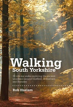
Walking South Yorkshire is a collection of 30 circular walks, between 2 and 8 miles (3 and 13 kilometres) in length, that explore the ancient woodland and rural visitor attractions around Sheffield, Rotherham and Barnsley.
Price: £12.00
This handy guidebook describes two National Trails, the Cleveland Way and Yorkshire Wolds Way, along with the Tabular Hills Walk. The three routes can be joined end-to-end to create a long-distance route of over 400 km of easy and enjoyable walking in the varied Yorkshire countryside, or undertaken as shorter individual walks.
Price: £14.95
Price: £16.95

Price: £14.95

Swaledale, regarded by many as the most beautiful of the Yorkshire Dales and a magnet for walkers who come the length and breadth of the country to sample this breath-taking scenery.
And yet despite that many walkers miss the harsh rugged hills that line the upper reaches of this dale and make the watershed that both surrounds and forms this iconic valley.


The Yorkshire Coast is hugely varied. There are Victorian seaside towns like Filey, Scarborough
and Saltburn, the very epitome of the classic English seaside resort and quaint fishing harbours like Staithes, Runswick Bay and Robin Hoods Bay. There are high
chalk cliffs, so highly symbolic of the English coast.


Walks Around is a series of walking books specially for those who like to get out and about in Yorkshire the easy way. Ten short walks of six miles or under chosen by local expert Colin Speakman.
Price: £2.99

Enjoy the best of Yorkshire with the Walks Around series. These easy-to follow short walks explore the stunning landscape of upper Calderdale, centred on the attractive town of Hebden Bridge.
Price: £2.99


